| |
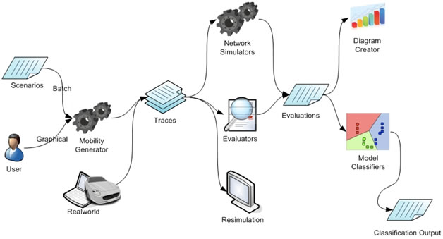
MobiSim is a mobility management
application, composed of many modules, using a pluggable
architecture and a form generator in order to
help researchers in the field of MANET (Mobile Ad-hoc NETworks) to deal
with mobility in these networks. User can create “scenarios”,
simulate them in graphical or batch
modes, resimulate the traces, evaluate measures
on the traces, create Excel diagrams by means of
the evaluations, and finally test mobility model recognition algorithms
on the traces. It supports plain text, NS format, and xml files for
traces and contains many mobility models, which can be mixed
together and configured graphically.
All of these can be extended with an XML
configuration file without any need to create additional GUI and
recompiling thanks to the form generator and Parameter
framework.
I developed the very first
version of this software for my BSc final project under
supervision of Dr. Rabiee and guidance from Mr. Mousavi in Sharif
University of Technology in 2007. Besides, I want to thank Mr.
Dabirmoghaddam for his codes in network analyzer tool. While this
software is an AS IS one (The project had and has absolutely no fund so
do not expect fast progress), I will appreciate if you have any idea to
improve it. Just feel free to contact me at moshref@ce.sharif.edu.
The third version
is out now 
The workflow of using MobiSim is as
follows:
In general, it has the following
features:
- Graphical model simulation
- Scenario/Batch model simulation
- Graphical scenario
creation form
- Implemented Models:
- 3D model: Gets a model
and moves nodes on a 3D environment
- Algorithms to set power ranges for
communication among nodes
- Various parameterable maps: Disk, Square, Reflectable maps,
Obstacle map,
and maps for geographical dependant models
- Graphical map designer
: A graphical UI to configure maps which is very useful for
Geographical dependant and complex models.
- Plain
text, XML trace, and NS-2 mobility trace files
- Mobility and network based
evaluators
- Excel file export for evaluators
- Mobility pattern recognition:
classifying input trace files in the known models, find the similarity
degree of real-world traces to each model
- Form generator which enables fast
development independant from UI concerns
- and the most important feature is
its modular architecture which enables the
developers to easily add a new model, map, evaluator, and trace formats.
Download
What's new in version 3?
- New GUI that simplifies user
interaction
- Tortoise model: A very general
transitional model, where you program nodes through sequence and loops
of transitions. The parameters for transitions (direction, speed,
duration, pausetime) can be randomized using many random distributions.
- Location initializer: Ability to
use various random and
deterministic algorithms to set initial positions of nodes
- Add obstacles to maps: Currently
supports rectangular obstacles but you can scale and rotate them.
- Range algorithms: Now you can set
ranges of communication during simulation
- Improve trace visulazation: Zoom
and Pan maps, new visualization methods and integrated codes.
- New Evaluators
- Recognize transition and
evaluate: Transition length, Transition time, Transition direction
change, Transition speed
- intermeeting time
- Fix bugs
- Cleaned code
What's new in version 2?
- Additional Models
- Levy
walk
- Model composer:
This is a model which acts as a composer of multiple models. Its
usecases contains:
- an emergency help group
finding for injured people. While the injured people have a low speed
model, the emergency group runs fastly
- a battle field containing
two groups some on the backup line and some on frontier behaiving
differently
- a battle field containing
two groups with a line between them where they seldom pass over it
- 3D
simulation:
- ability to define a 3D map
describing the height of each point
- ability to run available models
in a 3D environment with the defined map
- 3d representation for simulated
scenarios
- Graphical map designer
: A graphical UI to configure maps
- Additional trace formats: NS2 format
- New evaluators
- Clustering Coeficient
- Interference
- Location Distribution Variance
- Neighborhood instability
(Topology Change Rate)
- Network Diameter
- Repetitive Behavior
- Sort algorithm for evaluators
- Evaluation analyzer is more
powerfull
- more classification algorithms
added
- Fuzzy KNN Classification
- Fuzzy Guassian KNN
Classification (3 versions)
- Nearest Distance
- Group SVD
- Nearest Distance (SVD)
- a module for evaluating
classification algorithms and feature ranking implemented
- calculate the degree of
membership of a trace to each model
- calculate accuracy of each
classification algorithms
- Documentation
- A developer guide for extending
MobiSim is added
- Fixed Bugs
- FreeWay map enhancement
- Manhattan map input data error
fixed
- Model initialization exception
handling
- UI change to have the setup
button and start/pause command on hand
- Models should be able to add
columns in the trace files
- More detailed installation
documentation
Todo list
The next version, MobiSim v3
will have the following features:
- Additional models:
- Tortoise Model and
Randomized Tortoise Model (This will be one of the
strength points of MobiSim) DONE
- SLAW model TODO
- File model: Uses a trace file for
simulation! (usable for leader model in group models) DONE
- Ability to use various random and
deterministic algorithms to set initial positions of nodes DONE
- Ability to set fixed initial
point for a node DONE
- Trace Visualization:
- Integrate codes of all trace
visualization forms DONE
- Add a new foot-print
visualization with no fade but limited foot-print length DONE
- Ability to see foot-print of
nodes during simulation not only in visualization (resimulation) DONE
- Zoom and Pan in trace all
visualization panels DONE
- new GUI DONE
- Integrate TopoSim
into MobiSim DONE
- Change classifier package to
recognize features space, length measures and classifer algorithms TODO
- A new UI using Regular Expression
to define variable parameters in scenarios TODO
- 3D simulation:
- 3d environment evaluators TODO
- 3d distance difinitation in speed
model TODO
- New Trace formats
- Ability to define obstacles in the
map DONE
- Rewrite network analyzer
package DONE
- Save the last status of every
window TODO
- Save current simulation
configuration DONE
- Ability to use random functions
instead of numerical values for parameters DONE
- Seed management in random
generator functions DONE
- Ability to regenerate a
simulation using a specific seed DONE
- Change the GUI to improve the
usability
- A tree based GUI developed to
decrease the complexity of parameter configuration panels DONE
- A new initial GUI developed DONE
- Exception handling in simulation
initialization phase DONE
- Define a new file component to be
able to open multiple files that are not located in a folder TODO
- New Evaluators DONE
- Recognize transition and
evaluate: Transition length, Transition time, Transition direction
change, Transition speed
- intermeeting time
- Fix bugs:
- Use double timestep to
accurately manage reflection DONE
- Remove Transition and Track
class and make model movement functions simple (You can't believe how
much code I have deleted!) DONE
- Remove borderwidth,
borderheight and borderradius from reflective maps DONE
- Mobility based evaluators must
be available in the list of Network based evaluators (merge two types
of evaluators) DONE
- Fix Random Direction model
direction select algorithm
Publication
- S. M. Mousavi, H. R. Rabiee, M.
Moshref, A. Dabirmoghaddam, "MobiSim
: A Framework for Simulation of Mobility Models in Mobile Ad-Hoc
Networks", The 3rd IEEE International Conference
on Wireless and Mobile Computing, Networking and Communications (IEEE
WiMob 2007), New York, USA, October 8-10, 2007.
- S. M. Mousavi, H. R. Rabiee, M.
Moshref, A. Dabirmoghaddam,
"Mobility Pattern Recognition in Mobile Ad-Hoc Networks", ACM
International Conference on Mobile Technology, Applications and Systems
(ACM Mobility Conference 2007), Singapore, 10-12 September 2007
- S. M. Mousavi, H. R. Rabiee, M.
Moshref and A. Dabirmoghaddam, "Model
Based Adaptive Mobility Prediction in Mobile Ad-Hoc Networks",
The 3rd IEEE International Conference on Wireless Communications,
Networking and Mobile Computing (IEEE WiCOM 2007), Shanghai, China,
September 21-23, 2007.
- S. M. Mousavi, H. R. Rabiee, M.
Moshref, A. Dabirmoghaddam, "Mobility
Aware Distributed Topology Control in Mobile Ad-hoc Networks with Model
Based Adaptive Mobility Prediction", The 3rd
IEEE International Conference on Wireless and Mobile Computing,
Networking and Communications (IEEE WiMob 2007), New York, USA, October
8-10, 2007.
ScreenShots
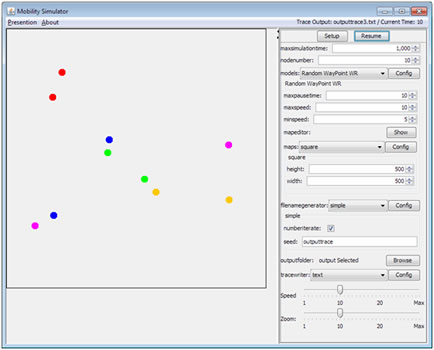
Mobility
Generator Screenshot
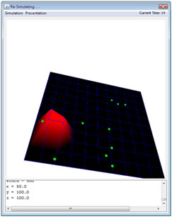
3d resimulator
window
|
|